| نسخه | ۱.۶.۴ |
| آخرین بروزرسانی | ۱۴۰۵/۰۳/۲۰ |
| تعداد دانلود | ۲۰۰ |
| حجم | ۳۵ مگابایت |
| نوع | برنامه اندرویدی |
| دستهبندی | سیر و سفر |
| سازنده | Tim Autin |


E-walk - Hiking offline GPS
آیا تابهحال برنامه E-walk - Hiking offline GPS را امتحان کردهاید؟ این برنامه با امکانات کاربردی و ویژگیهایی خاص، تجربهای متفاوت را برای شما رقم میزند.
دانلود برنامه E-walk - Hiking offline GPS
E-WALK
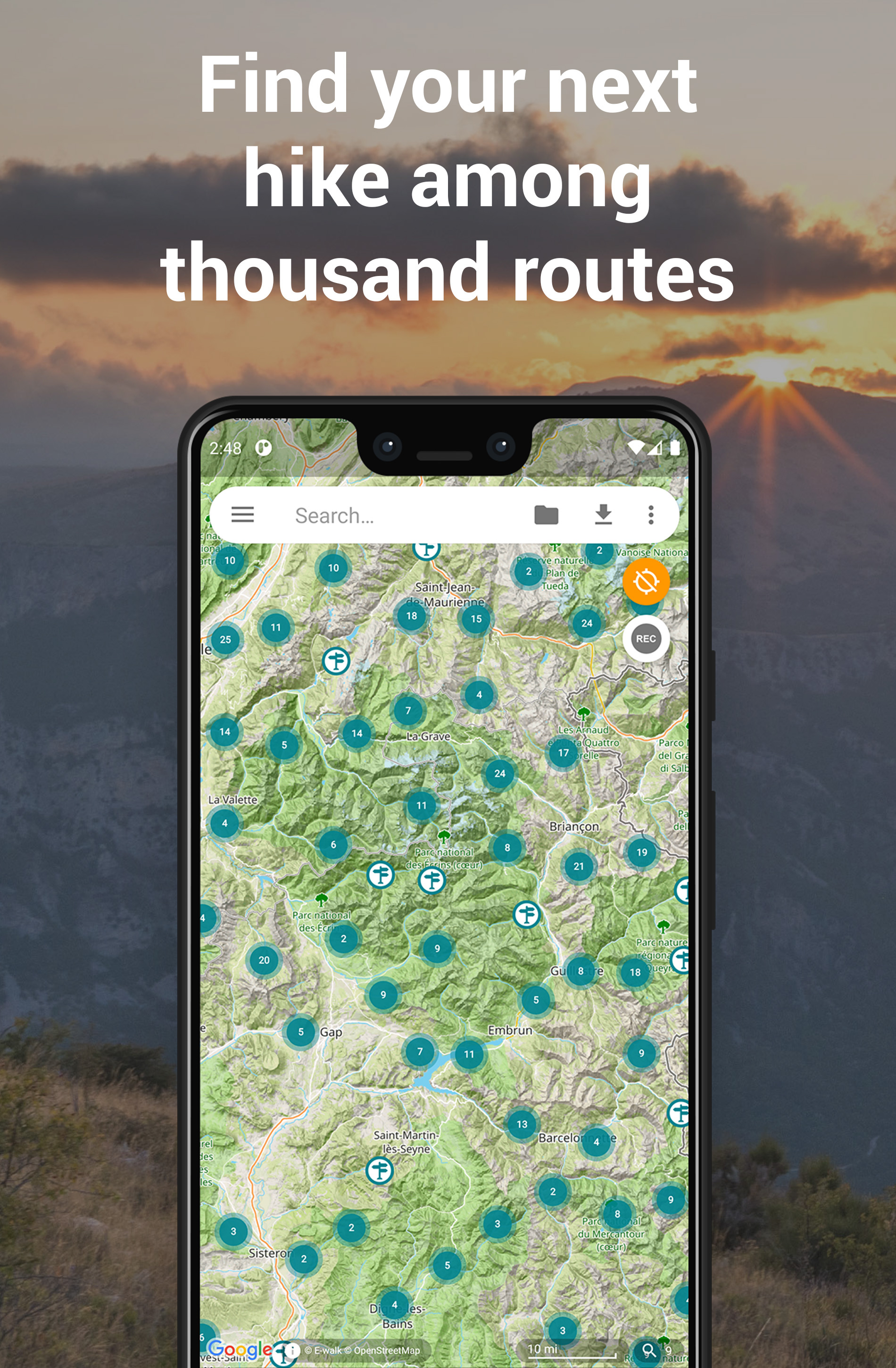
E-walk به شما امکان می دهد فعالیت بعدی خود را در فضای باز پیدا کنید، برنامه ریزی کنید و آن را ضبط کنید. E-walk همراه مناسبی برای فعالیتهای خارج از منزل (مانند پیادهروی، پیادهروی، دوچرخهسواری، ماهیگیری، شکار و غیره) و برای سفر به خارج از کشور است، زیرا میتوانید بهطور کامل از آن بهصورت آفلاین استفاده کنید.
ویدئو معرفی برنامه
گمشده در جنگل؟ E-walk شما را به ماشینتان بازمی گرداند. فراموش کرده اید که این بوتیک دوست داشتنی که سال گذشته در ونیز متوجه شدید کجا بود؟ E-walk حافظه شما را تازه می کند!
ویژگی های کلیدی E-WALK
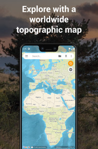
• نقشه توپوگرافی با وضوح بالا در سراسر جهان (E-walk Topo Map)، طراحی شده برای پیاده روی و فضای باز فعالیتها
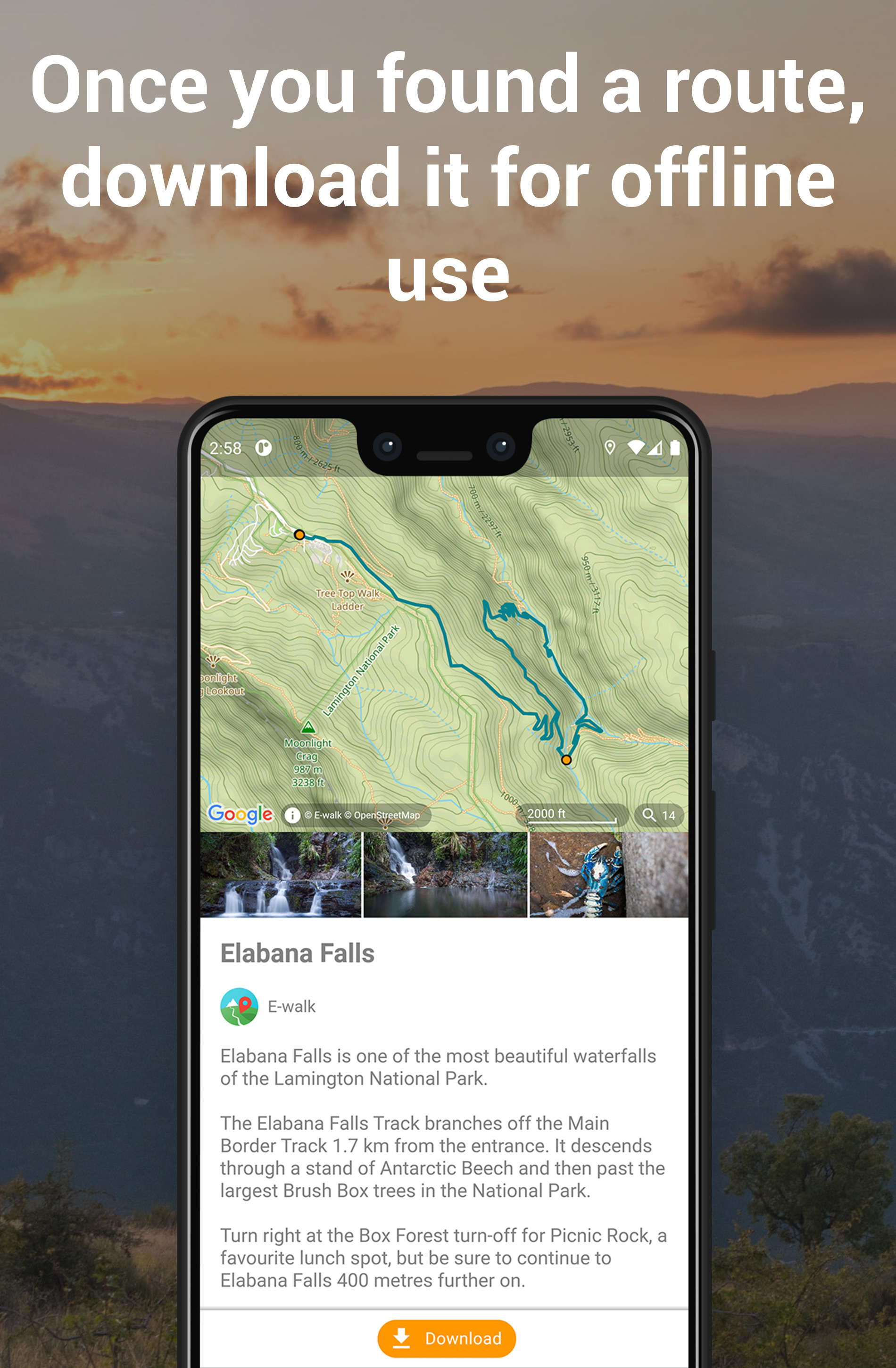
• ماجراجویی بعدی خود را در میان هزاران مسیر پیدا کنید، آنها را برای استفاده آفلاین دانلود کنید و مسیر خود را به اشتراک بگذارید (به یک حساب E-walk رایگان نیاز دارد)
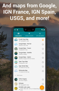
• ادغام کامل IGNrando' (https://ignrando.fr): مرور کنید مسیرهای IGNrando روی نقشه، محتوای IGNrando خود را همگامسازی کنید، مسیرها را در IGNrando بارگذاری کنید (به یک حساب رایگان IGNrando نیاز دارد)
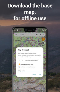
• دانلود نقشهها برای استفاده آفلاین بعدی (رایگان برای نقشههای OpenStreetMap و Wikimedia، با اشتراک E-walk Topo Map)
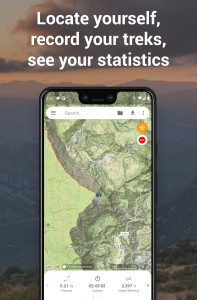
• مکان فعلی شما را روی نقشه نشان دهید
• مکان های جستجو (آخرین جستجوها برای استفاده آفلاین ذخیره می شوند)
• پیاده روی خود را ضبط کنید
• انتخاب نقشه های پایه مختلف (خیابان، ماهواره، زمین) و غیره...)
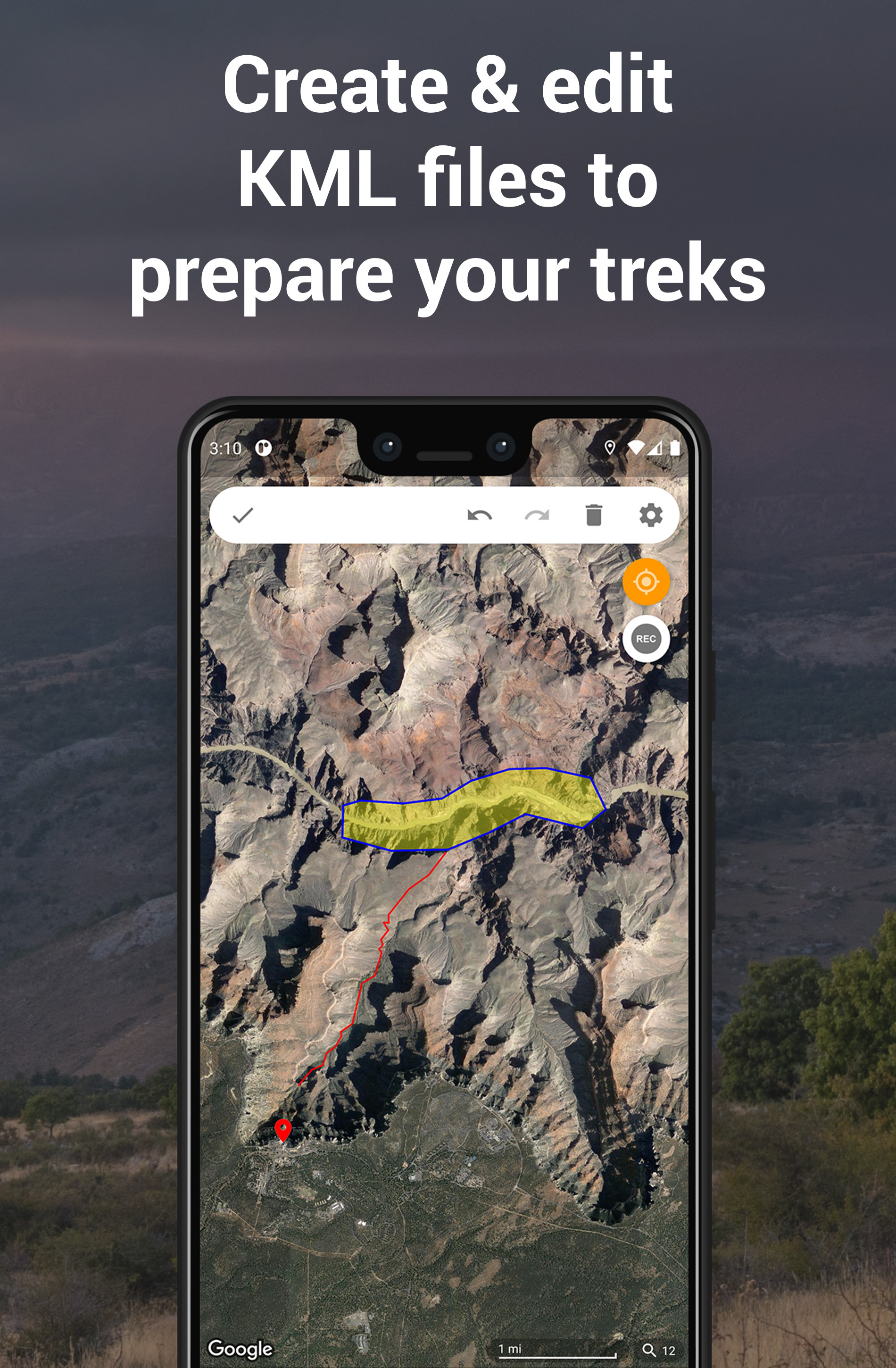
• با ایجاد و ویرایش فایلهای KML روی نقشه، پیادهرویهای خود را برنامهریزی کنید. یک فایل KML میتواند حاوی نشانگرها، خطوط و چند ضلعی باشد
ویژگیهای پیشرفته E-WALK
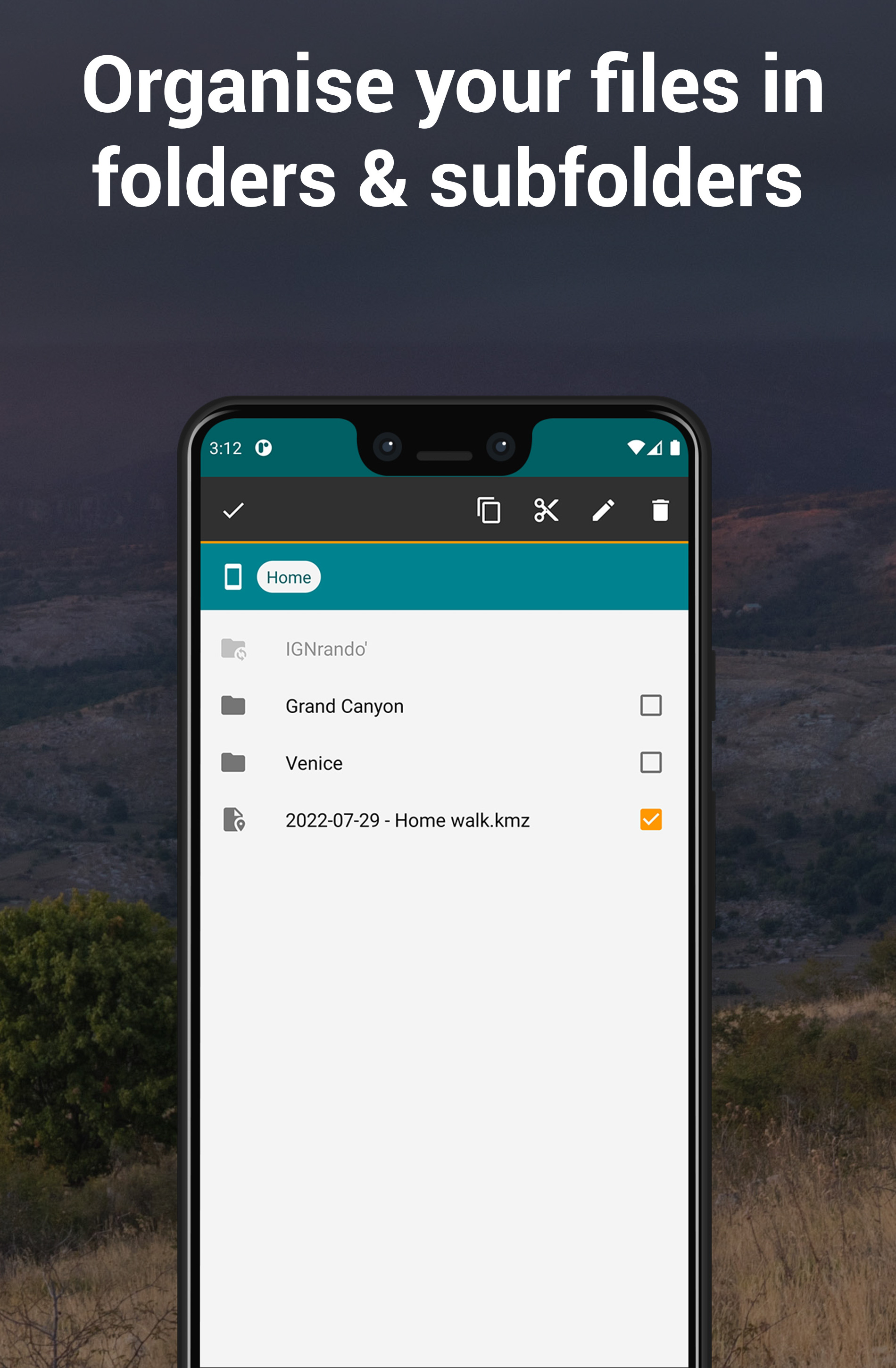
• مسیرهای پیادهروی خود را در پوشهها و زیرپوشهها سازماندهی کند
• نمایش نقشههای همپوشانی ( آب و هوا، جاده ها، مترو/اتوبوس، پیست های اسکی، نقشه دریا، و غیره...)
• موقعیت خود را از طریق ایمیل یا پیامک به اشتراک بگذارید
• موقعیتی را در سایر برنامه های جغرافیایی خود باز کنید (مانند نقشه های گوگل، Waze، TomTom، Sygic، Locus، Orux، MyTrails، و غیره...)
• افزایش را از طریق ایمیل، بلوتوث و غیره به اشتراک بگذارید... در قالب فایل KML (به طور پیش فرض) یا در قالب فایل GPX< br>• فایلهای GPX را وارد کنید (در قالب KMZ تبدیل خواهند شد)
• نقشههای سفارشی را در پروتکل XYZ اضافه کنید (به http://wiki.openstreetmap.org/wiki/Slippy_map_tilenames مراجعه کنید)
• نقشههای سفارشی را در پروتکل WMS
E-WALK PLUS
E-walk در حال حاضر دارای بسیاری از ویژگی های رایگان است. اما میتوانید E-walk Plus را بخرید تا موارد زیر را اضافه کنید:
• تبلیغات را حذف کنید
• مقیاسی روی نقشه داشته باشید
• دادههای خود را روی کارت SD خود ذخیره کنید
• ذخیره/بازیابی اطلاعات خود
• پشتیبانی از توسعه E-walk
E-WALK MAX
E-walk Max قفل تمام ویژگی های برنامه را باز می کند (به استثنای افزونه IGN Maps). شما می توانید آن را به صورت رایگان در طول 3 روز امتحان کنید. این شامل تمام مزایای E-walk Plus و موارد زیر است:
• دانلود E-walk Topo Map برای استفاده آفلاین
• مکث ضبط پیاده روی خود
افزونه IGN MAPS
افزونه نقشه های IGN (https://play.google.com/store/apps/details?id=com.at.ewalk.plugin.ign) نقشه های ارائه شده توسط موسسه ملی فرانسه را اضافه می کند. اطلاعات جغرافیایی و جنگلداری (http://www.ign.fr).
تماس
مشکل با E-walk؟ یک پیشنهاد؟ یک بازخورد؟ لطفا در ارسال یک ایمیل به contact@ewalk.app تردید نکنید!
تغییرات برنامه E-walk - Hiking offline GPS در نسخه جدید