
| نسخه | ۵.۰.۴ |
| آخرین بروزرسانی | ۱۴۰۵/۰۲/۰۶ |
| تعداد دانلود | ۳ هزار |
| امتیاز | ۴.۷ |
| تعداد نظرات | ۳۵ |
| حجم | ۱۸ مگابایت |
| نوع | برنامه اندرویدی |
| دستهبندی | سیر و سفر |
| سازنده | Marothia Techs |
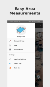


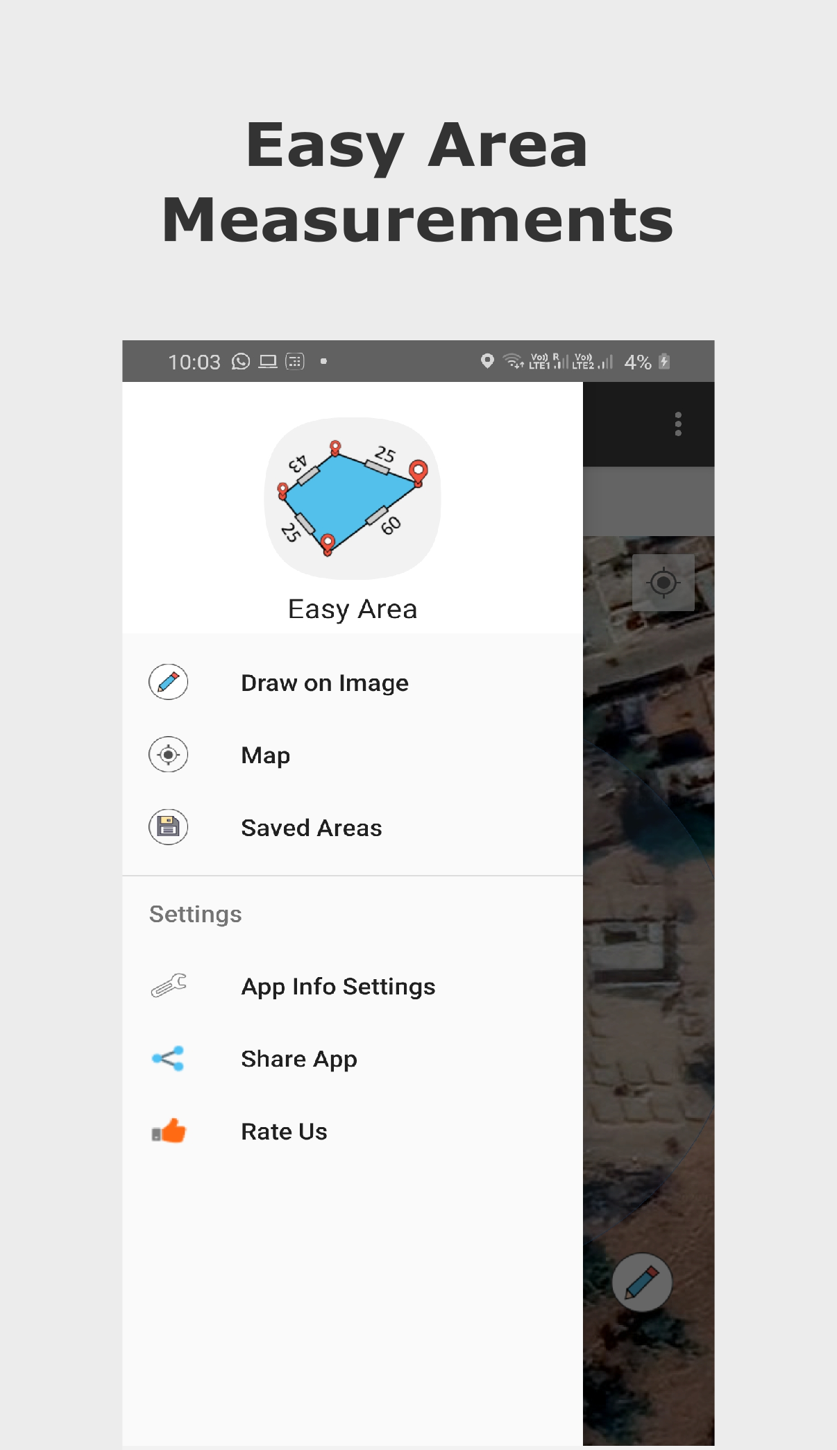
Easy Area : Land Area Measure
آیا تابهحال برنامه Easy Area : Land Area Measure را امتحان کردهاید؟ این برنامه با امکانات کاربردی و ویژگیهایی خاص، تجربهای متفاوت را برای شما رقم میزند.
دانلود برنامه Easy Area : Land Area Measure
Easy Area یک برنامه ماشینحساب مساحت برای اندازهگیری مساحت زمین، فاصله و محیط بر روی نقشه یا تصاویر به سادهترین روش است. یک مبدل واحد داخلی برای اندازه گیری مساحت ها و فواصل در واحدهای مختلف زمین هند وجود دارد
دو راه برای ایجاد اندازه گیری وجود دارد:
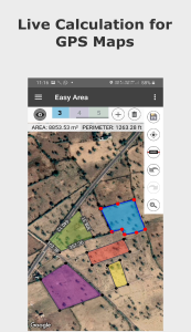
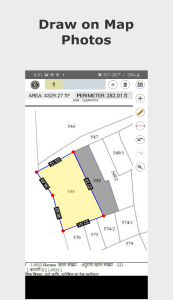
1) استفاده از نقشه ها - می توانید مکان زمین/زمین خود را جستجو کنید یا می توانید موقعیت فعلی و مرز منطقه ای را که مساحت یا مسافت برای آن محاسبه شود را بیابید.
- در نقشه ها، می توانید منطقه را با آگاهی صفر از اندازه گیری های قبلی بیابید.
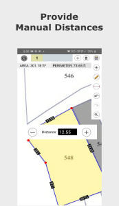
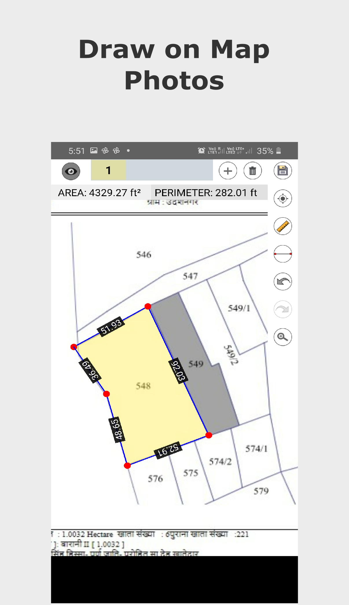
2) وارد کردن عکس - می توانید عکسی از زمین، مزرعه یا هر مورد دیگری وارد کنید. ساختار دیگر چند ضلعی به شکل تصادفی سپس به سادگی روی عکس وارد شده بکشید تا اندازه گیری ها را انجام دهید. برای تنظیم نسبت مقیاس برای تصویر، باید فاصله خط اول ایجاد شده را مشخص کنید.
- این ویژگی زمانی قابل استفاده است که اندازهگیریهای مسافتی از مرزهای زمین خود را توسط خود یا توسط پاتواری (حسابدار دولتی) منطقهای انجام دهید و نیاز به محاسبه مساحت آن اندازهگیری دارید.< br>
- به سادگی یک طرح خشن ایجاد کنید و طول های اندازه گیری شده را برای مرزها قرار دهید تا مساحت در زمان واقعی محاسبه شود.
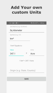
- مساحت محاسبه شده را می توان به هر واحدی تبدیل کرد. مبدل واحد دارای تمام واحدهای امپراتوری، واحدهای متریک است و همچنین شامل واحدهای هندی اصلی است که برای ثبت زمین در ایالات مختلف استفاده میشوند.
ویژگیهای عالی:
- دقت 100% مساحت های محاسبه شده با استفاده از هندسه مختصات و کروی.
- فاصله های نقطه به نقطه را برای هر خط ایجاد شده روی نقشه نمایش می دهد.
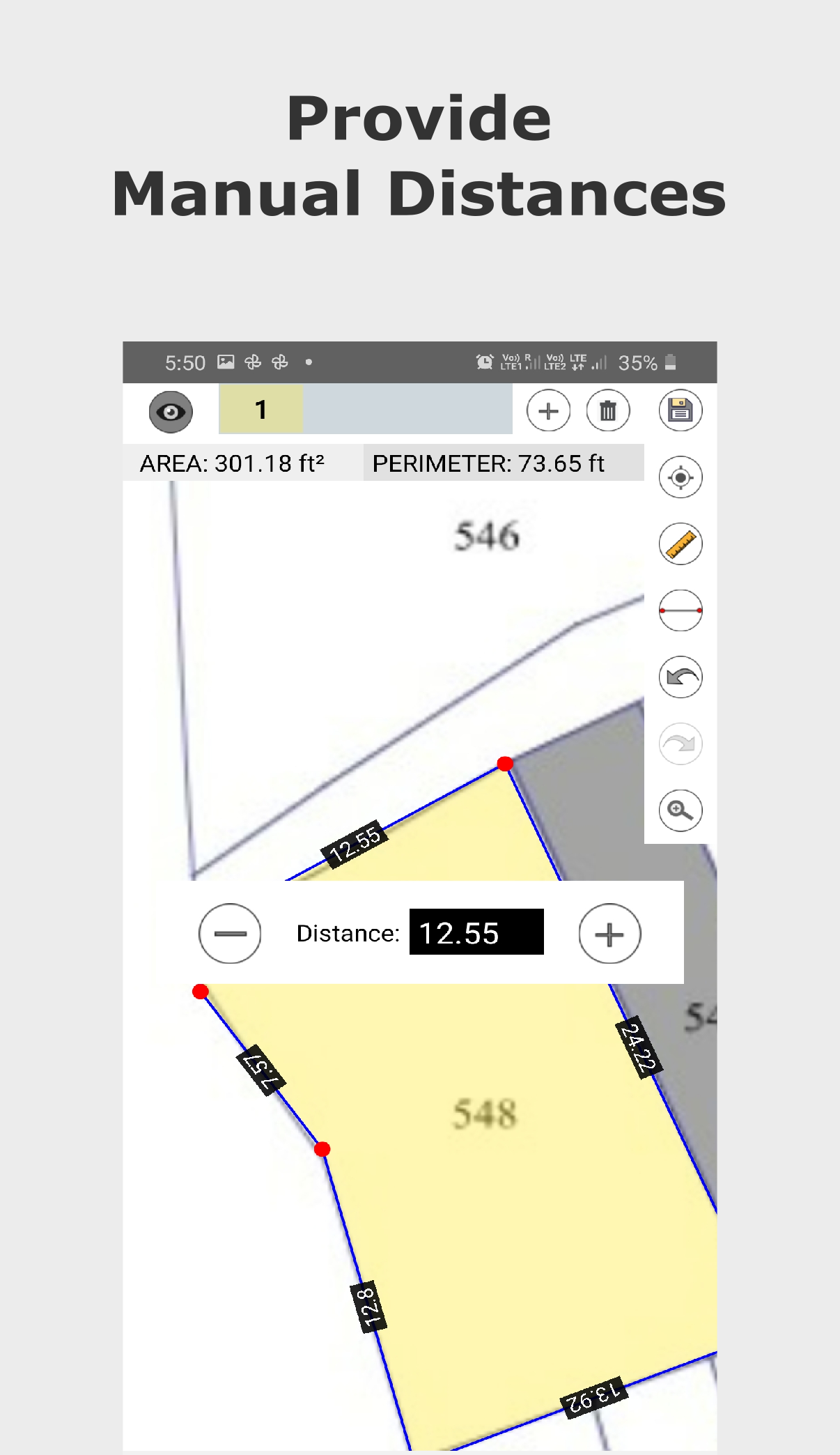
- فاصله های دستی. می توانید اندازه گیری های مرز زمینی را به صورت دستی وارد کنید. برای تغییر دستی طول آن خط، روی برچسب فاصله هر خط ضربه بزنید. در حال حاضر فقط هنگام اندازهگیری روی عکسها در دسترس است.
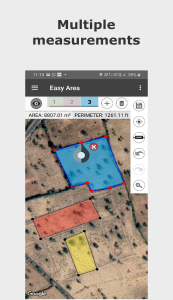
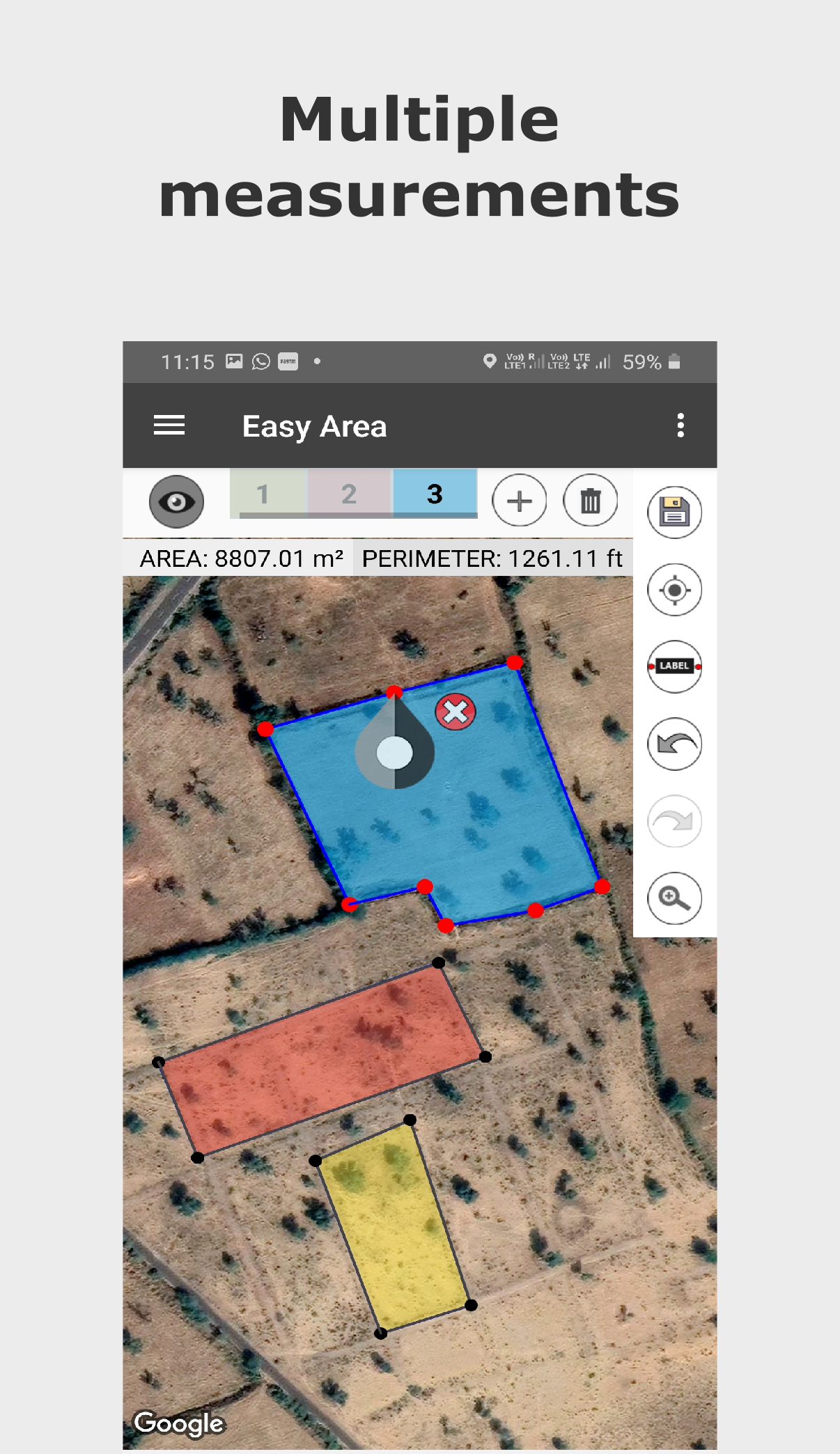
- چند لایه برای اندازهگیری چندین ناحیه در یک نقشه.
- ذخیره و بارگیری محاسبه شده اندازه گیری ها.
- پیوند منطقه اشتراک گذاری می توانید پیوند را به منطقه ذخیره شده خود به اشتراک بگذارید. کاربر دارای پیوند می تواند منطقه را روی پیوند به روز کند.
- بزرگنمایی و پیمایش بی نهایت نقشه با حرکات استاندارد.
- ابزارهای آسان برای ایجاد، به روز رسانی، حذف نقاط روی نقشه.
- برای افزودن نقطه جدید یک ضربه بزنید.
- برای انتخاب یک نقطه ضربه بزنید، نقطه انتخاب شده را بکشید و رها کنید تا به راحتی موقعیت را تغییر دهید.
- برای افزودن نقطه جدید در آن موقعیت، روی هر خطی دو ضربه سریع بزنید.
- واحدهای اندازه گیری مساحت و فاصله را با محاسبه فوری جدا کنید.
واحدهای اصلی هند شامل موارد زیر است:
- Bigha
- Biswa
- Aankadam
- Shatak
- Perch
- Rod
- Vaar (Gujarat)
- هکتار
>- Acre
- Are
- Guntha
- Marla
- Cent
- زمین و بسیاری دیگر..
تغییرات برنامه Easy Area : Land Area Measure در نسخه جدید- امکان تقسیمهای چندگانه منطقه (نقشهکشی زمین) اکنون فراهم است.
- جستجوی مکانها بهینهسازی شده است.
- اندازهگیری GPS پیادهروی اضافه شد.
- با نگهداشتن طولانی بر روی صفحه، علامتی برای جهتیابی اضافه کنید.
- اندازهگیریهای فاصله و مساحت در نقشهها جدا شدهاند.
- اکنون میتوانید منطقه را به دو بخش تقسیم کنید!
- ایجاد چندضلعی منطقه با استفاده از نقاط وسط آسانتر شده است.
- امکان ورود با حساب گوگل برای حفظ دادهها اضافه شد.
- اکنون میتوانید لینک نقشهای که ایجاد کردهاید را به اشتراک بگذارید!
- اکنون میتوانید واحدهای دلخواه خود را اضافه کنید!
- واحدهای مساحت و فاصله زمین هند اضافه شد.


برنامه خوبیه می تونید مساحت کشور ها رو هم ببینید
عالی
عالی ودقیق